Directions to Creekview
37.350198, -76.282044
Directions to 182 White Point Lane, New Point, VA
Note: GPS may not find it or it may show it as 48 Horn Harbor East. We highly suggest that as a backup, you print these directions. Don’t rely on the maps function of your cellphone. The closer you get to us, the more sketchy cell service becomes. Unfortunately, if you lose cell service, you won’t be able to call us for directions. GPS systems tend to maintain service and connection to their satellites and are therefore a bit more reliable.
Landline is 804 505-1158. Cell service (AT&T) doesn’t work
reliably but Verizon is great!
From Richmond:
From Washington, DC area and beyond
From Delaware Memorial Bridge and points north:
From Richmond:
Take 64 east to Route 33 to West Point exit 220. Continue on Route 33 through West Point. Don’t take first turn to Mathews, continue on 33 to stop light at Rt 17. There is a 7-11 on corner. Continue straight into route 198 (Glenns Road). Where 198 dead ends turn left on Rt198 – East (Dutton Road). Continue on Rt 198 which changes its name to Buckley Hall Road, but is still Rt 198. Continue straight, following signs to Mathews, at the Little Sue Rt198 becomes Rt198/14 East remain on 198/14. Turn right at the STOP sign, onto New Point Comfort Hwy to get to Main St, downtown Mathews you are now on Rt 14 (New Point Comfort Hwy). Continue through town on Main Street and stay straight through Port Haywood speed limit drop to 35mph and then returns to 55 mph. When the speed limit again drops, this time to 45 mph at the curve you’re getting close!
Turn left on 602/Sand Bank Road – they clear cut timbered on the right but its growing back rapidly and there’s a sign to to an New Point RV park/campground.
Immediately turn left on Rt 601 (Horn Harbor Road). Sign in on the left corner.
Road will turn left but stay straight on road, in about 100 feet it will become gravel you are on White Point Lane/Rt 692. Gravel road turns left, turn right on our “natural/Gravel” driveway to 182 White Point Lane. Be careful it’s narrow.
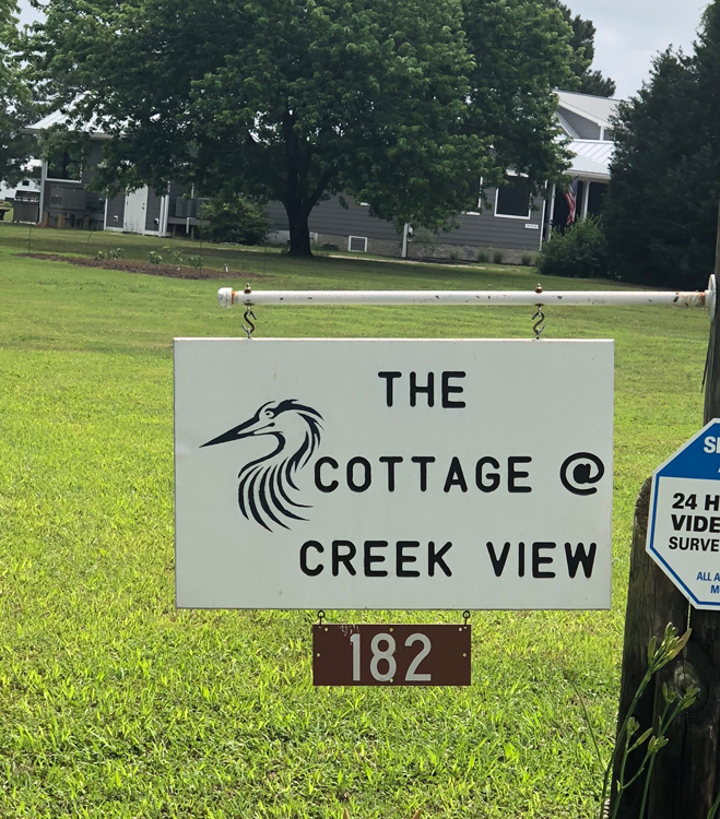
You will see the White Sign for “The Cottage @ Creek View”
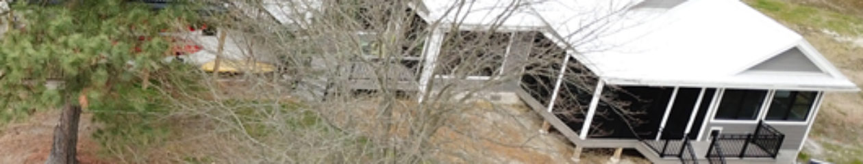
 We’re the Gray House with the 3 car garage with a room over the top. Of course you can’t miss our Red Barn
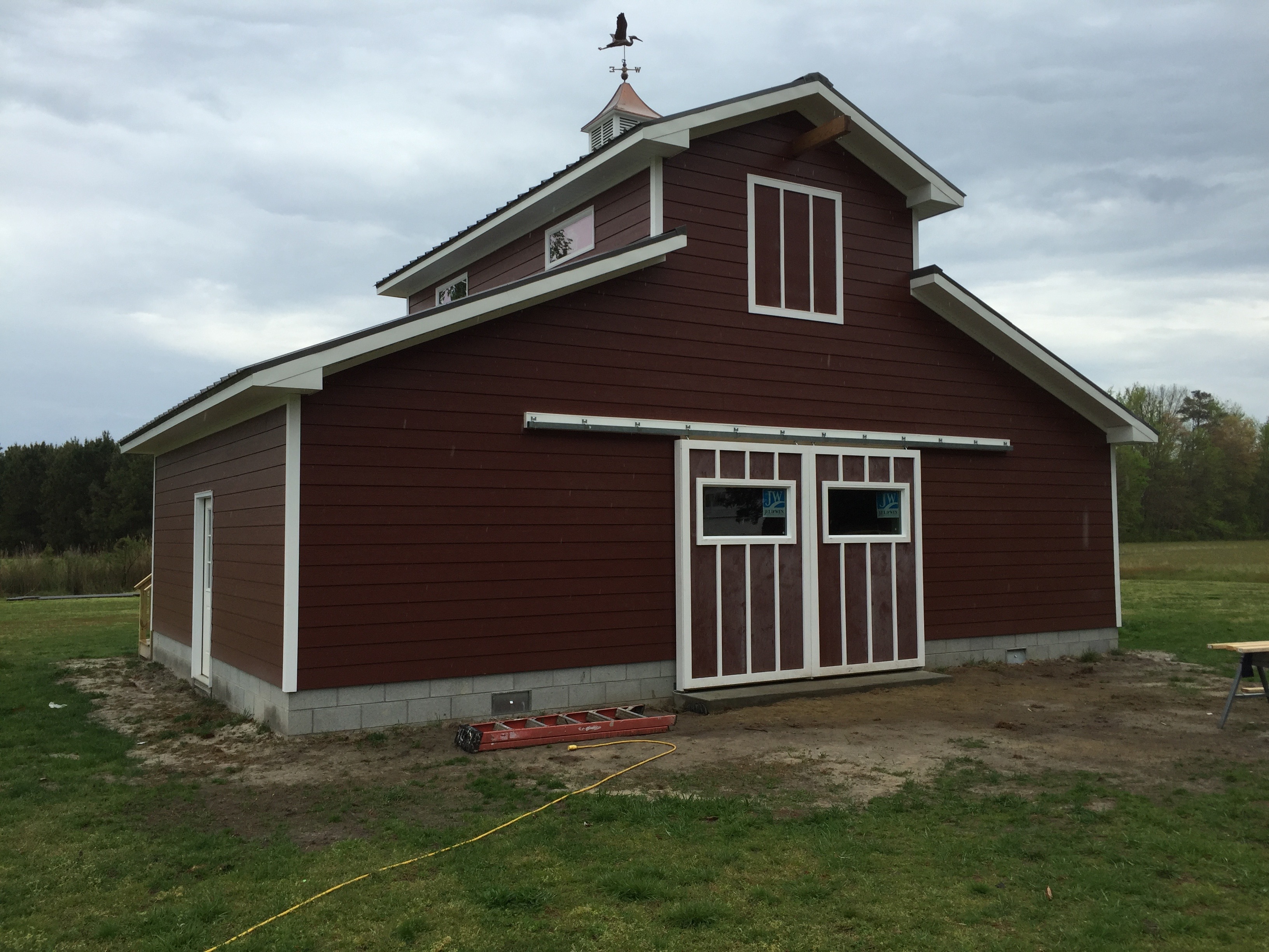
From I495 (Capitol Beltway) take Branch Avenue Route 5 exit South. (To bypass Waldorf and La Plata follow Enhanced Directions) Continue onto Crain Highway Route 301. After about 45 miles, turn left on Route 17 (Tidewater Trail). During that 45 mile trek, you will have crossed the Nice Bridge which crosses the Potomac River (toll) and indicates you have crossed into Virginia.
Stay on Tidewater Trail Route 17 for about 50 miles. Turn left onto Glenns Road Route 198. There will be a BP on the right before you make the turn, a 7-11 on the left.
Where 198 dead ends turn left on Rt198 – East (Dutton Road). Continue on Rt 198 which changes its name to Buckley Hall Road, but is still Rt 198. Continue straight, following signs to Mathews, at the Little Sue Rt198 becomes Rt198/14 East remain on 198/141. Turn right at the STOP sign, onto New Point Comfort Hwy to get to Main St, downtown Mathews you are now on Rt 14 (New Point Comfort Hwy). Stay straight through Port Haywood speed limit drops to 35mph and then returns to 55 mph. When the speed limit again drops, this time to 45 mph you’re getting close!
Turn left on 602/Sand Bank Road – they clear cut timbered on the right but its growing back rapidly and there’s a sign to to an New Point RV park/campground.
Immediately turn left on Rt 601 (Horn Harbor Road). Sign in on the left corner.
Road will turn left but stay straight on road, in about 100 feet it will become gravel you are on White Point Lane/Rt 692. Gravel road turns left, turn right on our “natural/Gravel” driveway to 182 White Point Lane. Be careful it’s narrow.
You will see the White Sign for “The Cottage @ Creek View”
From Delaware Memorial Bridge and points north:
Follow signs to I-95 South
Take exit 62 on the right to I-895 S towards Baltimore Harbor Tunnel Thruway. Keep left on I-895 South. Take exit 6 on the right to I-895 Bus Spur S toward I-97 S toward Annapolis
After 10 miles, take exit 7 onto MD-3 South toward MD-32 W Bowie. In 6/10 of a mile, take a slight left turn onto Crain Highway toward Bowie/Gambrills. Crain Highway is both Route 301 and Route 3. You will stay on Route 301, through Bowie, through, Waldorf, over the Nice Bridge and the Potomac River, into Virginia.
To bypass La Plata and Waldorf congestion, use these directions. But be aware, two lane roads and 45 mph speed limit
South of Rt 5, left on Croom Station Road.
After 1.6 miles, turn left on Croom Rd.
After 13 miles turn left on Aquasco Rd.
After 6.5 miles turn right on Prince Frederick Rd.
At roundabout, take 2nd exit to stay on Prince Frederick Rd.
Go 600 ft to 2nd roundabout, 2nd exit to Prince Frederick Rd.
In 3.6 miles, turn left onto Oliver’s Shop Rd.
In 3.5 miles, turn right onto Charles St.
In 1 mile, turn left onto Pena’s Hill Rd.
After 5.3 miles, turn right onto Budds Creek Rd.
After 1.6 miles, turn left onto Crain Highway, US-301.
Follow your GPS to Tappahannock using Route 17, the Tidewater Trail. If you’re hungry and its lunchtime, check out NN Burger, Northern Neck Burger at 303 Queen St 804-925-6100 in the center of Tappahannock.
After about 75 miles, turn left on Rt 17 Tidewater Trail. Continue for about 25 miles.
Outside Tappahannock (about 25 miles south of Tappahannock) from Route 17, turn left on General Puller Highway Rt 33 toward Saluda.
Follow Rt 33 General Puller Highway through Saluda, Locust Hill, and farms for 11 miles. Take a slight right by the Hartfield fire station onto Twiggs Ferry Rd Route 3.
Cross the Piankatank River Bridge, then turn left onto Rt 198, Buckley Hall Rd by the Gas Station/Convenience store.
In about 9 miles, turn right onto Main Street and downtown Mathews.
In about 7 miles turn left onto Sand Bank Rd.
Immediately turn left onto Horn Harbor Rd
Bear right on White Point Lane.
Road will turn left but stay straight on gravel road which is White Point Lane/Rt 692. Gravel road turns left, turn right on “natural/Gravel” driveway to 182 White Point Lane. Be careful it’s narrow.
You will see the White Sign for “The Cottage @ Creek View”